|
|
|
|
|
|
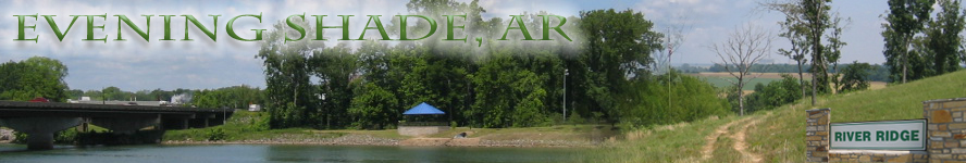
River Ridge is a restricted subdivision lying along the west bank of the White River and extending westwards to Arkansas Route 14. It comprises approximately 472 acres, all of which lie in Independence County, Arkansas, and has been subdivided into 72 lots, of which 32 have frontage on the White River.This is a spectacular property with outstanding views and access to the White River in the Subdivision. It compares well with properties throughout the nation, but often at a fraction of their costs.
The River Ridge Subdivision was started by a group of real estate promoters in Melbourne, Arkansas in the Spring of 2000. Subsequently, the First Addition to River Ridge Subdivision was added in the Spring of 2001, and the Second Addition to River Ridge Subdivision was added in the Spring of 2006.
The Subdivision is located 9.5 miles southeast of Batesville, Arkansas on State Highway 14, and residents can reach US Highway 169 on the south side of Batesville on Arkansas 14 without encountering a stop sign, stop light, or any other hindrance except the stop sign at the exit of the Subdivision. Shopping facilities are also located along US 169 south of Batesville along with the municipal airport. River Ridge is 97 miles from Little Rock (of which over 25 miles are four lane road and 62 miles are interstate), 112 miles from Memphis, Tennessee, and 162 miles from Branson, Missouri (for country music fans). Access is fast and easy.
The geological feature that gives River Ridge its name is a sandstone ridge thrusting upwards toward the northeast and approximately two miles long. It borders and confines the White River on its southwest side northeast of Rosie, Arkansas. This ridge lies well above the White River at an altitude of 340 to 370 feet about sea level. The top of the ridge features a relatively level area five to six hundred feet in width, making the top of the ridge ideal for home sites. The ridge slopes gently downwards in a southwesterly direction to rolling foothills. The high water mark elevation of the White River at the foot of River Ridge is approximately 120 feet above sea level. Photo 1 shows the ridge looking south from Lot 7 to Lot 12. Photo 2 shows the same area looking north from Lot 12. Photo 3 shows the ridge looking south from Lot 15. Photo 4 is taken looking north from Lot 72. The power plant in some photographs is the Independence County power plant for Entergy located at Newark, Arkansas, and is a coal-fired unit. The prevailing wind is from the west, so River Ridge experiences little to no pollution from the power plant's emissions.
A logging road exists from River Ridge Lane on Lot 23 to the river bank, and then turns north along the river to Lot 6. This road provides access for development on the bank and area sloping up to the top of the ridge. Photo 5 shows the road on Lot 23 looking toward the river, and Photos 6 7 & 8 show the road along the bank. Photo 15 shows the White River bank from Lot 23 as of November, 2006.
Primary access to the White River for boating is provided on the "Common Area" at the south end of River Ridge Lane. A concrete boat ramp leads down to the river as shown in Photo 9. This photo also clearly shows the general size and appearance of the White River along River Ridge. Purchase one of the river frontage lots and build your own private dock on the White River!
Views to the northeast are spectacular as the land north and east of the White River is low-lying farmland in the White River floodplain that joins the Mississippi delta floodplain at Newport, some twenty miles to the east. The White River floodplain becomes increasingly narrow as one travels up-river to Batesville where the river is controlled by a weir. Photos 10 and 11 show views from the ridge toward the northeast.
The White River is one of the major rivers in Arkansas, beginning in southwestern Missouri, impounded at Bull Shoals Lake, and flowing southeastwards to a point east of Arkansas Post in southeastern Arkansas. There it connects to the Arkansas River by means of the Wilbur Mills Canal and also continues east to the Mississippi River. More reliable than the Arkansas River for navigation, the White River was a major supply line for Union gunboats during the Civil War after Arkansas Post was captured. Photos 12 and 13 show the White River at Batesville.
Using the Subdivision's boat ramp, residents can enter the White River and have access from Batesville to the Mississippi River and beyond. According to a US Army Corps of Engineers spokesperson, a property owner can travel by boat via the White and Mississippi rivers to the Intra-Coastal Waterway and anywhere accessible by water on the Atlantic and Gulf Coasts. Docks may be put in the White River on any and all river frontage lots after acquiring the appropriate permit from the US Army Corps of Engineers.
Water to the Subdivision is provided by the Southside Water Authority, and the mains are already present throughout the Subdivision. Hook-up costs are $450.00 plus a meter deposit of $60.00. In the event that the water main lies across the road from a lot, an additional road boring charge of $250.00 is assessed.
Electric service is supplied by the Entergy Corporation and service is already available in the Subdivision. If overhead lines are acceptable to a property owner, there are no new construction hook-up charges for a full-time residence.
The Subdivision has no sewer service, and all lots will need to install individual septic systems. All lots less than 10 acres are being sold with a septic system permit as noted in the lot detail from the Arkansas Department of Health and Human Services for a three bedroom residence up to 3,000 square feet. Ten acre or larger lots do not require septic permits for lot sales. If a purchaser wishes to build a larger residence or locate his home other than where specified by the permit, the modification or upgrade of the permit will be the purchaser's responsibility. The cost of the permit is being borne by the seller, and each lot is offered with an allowance for the cost of a septic system for that lot as estimated by local installers.
Since the building of residences increases the desirability of the Subdivision, Lakeside Ranch offers a rebate to new purchasers who build a main residence within 12 months of purchase contract execution. Proof that the roofing for the main residence is completed within the required time is sufficient for the rebate to be paid to the Buyer. The amount of the rebate is equal to the Buyer's earnest money, but in no case greater than $2,000.00.
Closing costs for the purchase of lots in River Ridge are unusually low when compared to those encountered on the East Coast, West Coast, or the more industrialized states. Other than state tax stamps, recording fee of $11.00, and half of the closing agent's fee (currently $125.00), there are only the purchaser's costs associated with his lending institution, if any. Lakeside Ranch bears the costs for the percolation tests and septic system permits as noted above as well as the title insurance. THERE ARE NO IMPACT FEES or the like.
Prices are subject to change without notice. Bank financing is available.
The prospective purchaser should note that labor and building costs are substantially lower in Northern Arkansas than many localities in the Nation. Excellent homes can be built for sixty to eighty-five dollars per square foot, and a good mason or carpenter can be obtained for twenty dollars per hour. The cost of the percolation tests in River Ridge were $250.00 per lot, and clearing was accomplished by heavy machinery costing $50.00 per hour. By way of comparison, in 2003 a forty gallon water heater was purchased and installed with the required 2 permits by a plumber in Atlanta, Georgia, for $570.50 -- in Franklin, Arkansas, the same water heater was purchased for $149.95 one month later and installed by the purchaser without needing a permit.
For those who might wish to involve themselves in extensive landscaping, the current price for a 23 ton truckload of topsoil delivered to a lot in River Ridge is $200.00. A reference list of vendors for topsoil and other services is given elsewhere on this site, but please note that no particular builder or supplier is required or specified in the Lakeside Ranch purchase contract.
The two major roads in the Subdivision, River Ridge Road and River Ridge Lane, are county roads and maintained by Independence County. Both roads were resurfaced and paved with "Chip & Seal" in May of 2006 by Lakeside Ranch at the firm's cost. Discussions have been held with Independence County officials, and since the roads already meet county standards and asphalt paving can be laid directly on the "Chip and Seal" surface, it is possible that Independence County might upgrade the roads to asphalt after a respectable level of citizens reside in the Subdivision.
The Subdivision is subject to restrictions as given in separate documents for the original Subdivision, First Addition and Second Addition. The intent is to provide a strictly residential community of high standards and pleasing appearance. These restrictions are given elsewhere on this site (Click Here). Lots 1-33 are in the original Subdivision, 34-69 in the First Addition, and 70-72 in the Second Addition. Lots 1-32 are the White River frontage lots, the remainder are either wooded or pasture land west of River Ridge Lane which runs southeast to northwest along the top of the ridge.
All White River frontage lots are over three and less than four acres in area. Most have approximately 200 feet of frontage on River Ridge Lane and approximately the same along the White River. (Click here to see the Subdivision map.) The boundary distances are given in the Lot Detail (Click here) for each lot. Lots without river frontage are generally five acres or more in area.
The River Ridge lots are priced to sell rapidly. Comparable White River frontage lots from 1/2 to one acre currently sell between $55,000 to $100,000. River Ridge's frontage lots are from three to four acres, selling from $47,400 to $53,900, at an average of 21.5% below the appraisal of $63,875 per lot. Comparable non-river wooded lots in exclusive subdivisions average $5,745 per acre, whereas River Ridge's average is $4,409 per acre, 23.3% below appraisal, and its lots have access to a boat ramp in the Subdivision. In addition, River Ridge lots do not include the road easements in their acreage although most developments count the acreage to road centers. With fifty-foot road easements, most lots would gain from .1 to .4 acres in area if River Ridge followed normal practice. When one compares a River Ridge river frontage lot with a fractional acre lot in a subdivision on the Tennessee River without river frontage but priced at $30,000, the River Ridge lot looks startlingly under-priced.
The development got off to a slow start without adequate roads acceptable to the County for maintenance, clearing of brush and foliage for views, hillside sculpturing, water service, and local ownership. These defects were remedied in the spring of 2006. The roads were re-surfaced in 2006, culverts were added, the intersection with Arkansas 14 was upgraded, and Independence County accepted the roads for county maintenance. Water service was worked out with the Southside Water Authority, a number of lots were cleared, and the general appearance of the Subdivision enhanced. Even without these improvements almost half of the available lots were sold with minimal advertising. Until March of 2006, there was not even a sign at the entrance to the Subdivision from Arkansas 14 announcing the existence of River Ridge (Entrance).
Following the improvements in 2006, advertising in regional and national publications was begun in the late summer of 2006, and sales of both river frontage and off-river lots were brisk for a year. In the Fall of 2007, a phenomenon began to raise its ugly head that other real estate and development firms were also experiencing -- namely that buyers contracting for lots failed to obtain bank financing due to inadequate credit ratings. By February of 2008 sales came to a standstill, and Lakeside Ranch ceased advertising. At the same time, the principals of Lakeside Ranch pulled out of the stock market, leaving only electric utility and gold mining stocks in preparation for an expected downturn that unfortunately materialized later in 2008 and to the current time. Lakeside Ranch purchased other properties in Sharp and Izard counties for development so as to be positioned advantageously when the United States begins to recover. For buyers interested in smaller lots in a small town, the Lakeside Ranch Millcreek Plantations development in Melbourne offers lots from just under one acre to two and a half acres, and in addition, one commercial lot of slightly over six acres, and another commercial lot on the main highway of .6 acres backed by a residential lot of just under a half acre. At the current time advertising is minimal to reduce costs during these hard times.
Land prices in the three counties of Independence, Sharp and Izard have held relatively firm with homes declining somewhat whereas raw land prices are still advancing. Prospective buyers from the East and West Coasts must understand that Northern Arkansas did not participate extensively in the run-up of home and land prices that were experienced in other areas such as Florida, Texas or California.
Lakeside Ranch also is offering a newly built residence of about 2,350 square feet on Lot 7, one of the White River frontage lots for just over $100.00 per square feet plus the cost of the lot. This is a luxurious executive home with hardwood floors, granite counter tops, dynamic lighting, high ceilings, and many extras. Another new home is being offered on Lot 71 that is even more luxurious, but larger at about 3,250 square feet.
At the current time there are fourteen residences in River Ridge plus two that are not officially in the subdivision but are on the subdivision's roads. There are only nine river frontage lots still available from Lakeside Ranch and fourteen off-river lots out of an original 72 lots.. This is a spectacular opportunity for those wishing to make a sound investment, move to a rural/suburban setting, build a second or vacation home, or get away from the problems on the East, West or Gulf coasts.If you are worried about hurricanes, oceans rising due to global warming, earthquakes like those threatening the West Coast, forest fires (River Ridge's forest is Cedar and eastern hardwoods), not having an adequate supply of water, or unfriendly neighbors, then River Ridge is the place for you!
If you want lush and hilly property, an area with traditional values, moderate weather with only occasional light snow in winter, light traffic, a low crime rate, helpful neighbors, low cost housing and labor services, and the availability of fishing, hunting, and a commendable array of outdoor life, then River Ridge is the place for you!
In particular River Ridge offers the White River, safe elevations from floods, outstanding views, large lots, city water, electric, and pre-existing septic system permits, easy access to Little Rock and Memphis, and lots of recreational opportunities. This is the place for you!